Trail Walking La Seyne-sur-Mer - Rando Saint-Mandrier - Photo
 Fab-Oz
Fab-Oz

User

© OpenStreetMap contributors
Length
Length
11.3 km
Max alt
Max alt
102 m
Uphill gradient
Uphill gradient
316 m
Km-Effort
Km-Effort  
15.5 km
Min alt
Min alt
-1 m
Downhill gradient
Downhill gradient
315 m
Boucle
Boucle
Yes
Creation date :
2021-07-18 12:36:08.26
Updated on :
2021-07-18 16:45:12.047

(0 Reviews)

Walking
Walking
3h23
Difficulty : Medium

Scan this QR Code to open this trail in the SityTrail application

FREE GPS app for hiking

Logo SityTrail SityTrail

IGN / Geographical institutes

Download SityTrail from the App Store Download SityTrail from Google Play

Logo SityTrail SityTrail Plus

The world is yours!

Download SityTrail from the App Store Download SityTrail from Google Play Download SityTrail on Huawei AppGallery

About

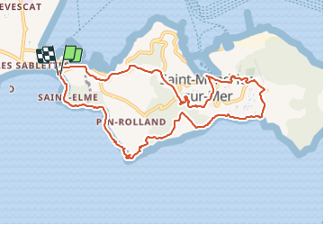
Trail Walking of 11.3 km to be discovered at Provence-Alpes-Côte d'Azur, Var, La Seyne-sur-Mer. This trail is proposed by Fab-Oz.

Description

Au départ des Sablettes
ATTENTION à la pointe de Saint-Elme,.le sentier est normalement interdit. C'est dangereux par endroits avec éboulements, à vos risques et périls.
Ensuite le sentier du Littoral à Saint-Mandrier est très bien indiqué et sympathique.

Elevation profile

Positioning

Country:
France
Region :
Provence-Alpes-Côte d'Azur
Department/Province :
Var
Municipality :
La Seyne-sur-Mer
Location:
Unknown
Start:(UTM)
735959 ; 4773543 (31T) N.


Close
My subscriptions